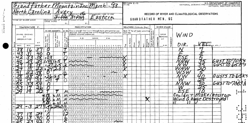
While the blizzard of a lifetime raged on the morning of March 13, 1993, the weather observer on Grandfather Mountain made a daring attempt to reach the ranger station to take his usual daily measurements. That day, however, was far different from any other day he’d experienced on the mountain. An area of low pressure was lifting out of the Gulf of Mexico, dumping feet of snow along the spine of the Appalachians and creating a near-perfect high wind setup. The observer never made it to the summit that day, turned away by the most extreme winter conditions in generations. As such, no meteorological observations were taken. Winds likely exceeded 125 mph, with localized gusts > 175 mph along the rocky ridgeline of Grandfather Mountain State Park. Nearby Mount Mitchell reported a unbelievable 50″ of snow between the 12th and 14th of March, making it the snowiest 3-day period at any North Carolina observation station.
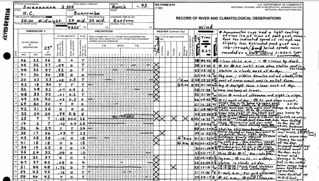
Some of you may remember the Blizzard of ’93, dubbed the “Storm of the Century”, while others have heard stories of the supposed twenty foot snowdrifts and 100 mph winds. Sure, some of those stories were exaggerated, but you’ll find some incredible nuggets of truth if you look back at the meteorological records. Winds didn’t exceed 100 mph in the valleys, but locations above 4000′ really did endure gusts beyond 100 mph on the morning of the 13th, causing widespread damage and power outages. A COOP observer a few miles from Asheville reported a max gust of 101 mph (estimated to 105-107 mph) at 4300′. Snow totals in the Boone area were around 3 feet, so it’s possible drifts reached to the tops of single story buildings. Other outlets have written summaries of this event from the humanitarian perspective, but I want to focus on the weather observations that defined the Storm of the Century in the Carolinas.
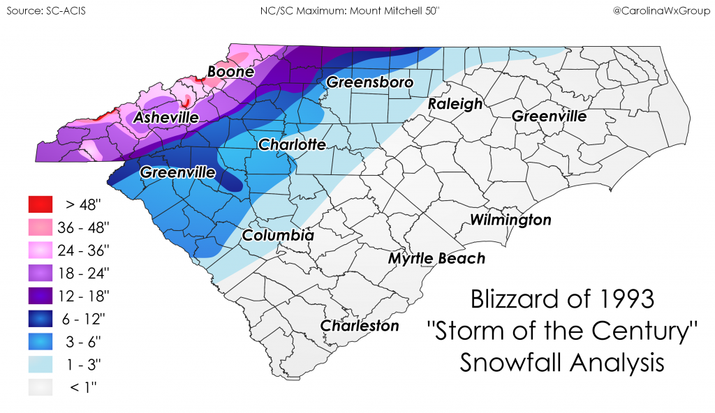
The footprint of 18″+ snowfall totals across Western NC is one of the largest on record, with totals exceeding 4 feet on mountains such as Mt. Mitchell, Clingmans Dome, Mt. LeConte, and Roan Mountain. It’s still the biggest snowstorm on record in Asheville and Boone, with 18″ and 30″ 3-day totals, respectively. Along the coast, warmer temperatures kept the snow at bay, but precipitation totals ranged in the 1-3″ range, with isolated totals exceeding 4″. Widespread gusts between 50 and 70 mph were reported in the warm sector, with a gust to 93 mph on Fryingpan Shoals Tower Light Tower off the NC coast.
If you’ve never taken a jaunt through the original COOP forms on March 13, 1993 in the Southern Appalachians, I highly recommend checking them out and reading the fascinating meteorological accounts of COOP observers. Two forms have always stuck out to me for their vivid descriptions: Swannanoa 2 SSE and Grandfather Mountain. The words “Couldn’t make it to top, wind gauge destroyed” ring in my head this time of year. I can’t image the ferocity of the wind on Grandfather Mountain throughout the storm to destroy such hearty anemometers. Likewise, 100+ mph winds at the Swannanoa 2 SSE station were catalogued in delightful detail on the original form.
Do you have a story from the Blizzard of ’93? Share it with us on Facebook or Twitter, or send us an email at carolinawxgroup@gmail.com! We’d love to hear from you.